|
Issued: 0530hrs Monday 6th August 2018
Duty forecaster: Garry Nicholson
Thunderstorms breaking out across France
 Monday Monday
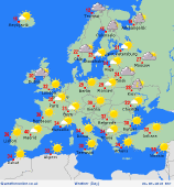
Slack high pressure continues to influence much of Europe, with ongoing hot and dry weather for many countries. Temperatures into the 40s again for southern Spain and Portugal. Mid-30s for France and Italy. Thunderstorms breaking out over the west & central Alps, and locally over the Pyrenees. A few thunderstorms also for the mountains of Romania. Lots of sunshine for the Mediterranean, including Greece and the Aegean Sea.
Warm and sunny for the Low Countries and Germany, 29 to 32C. Less hot for Poland, 24 to 29C, highest temperatures in the west. Cloudy with rain or drizzle for south-west Norway. Showery rain for Finland and northern Sweden, but much of Sweden should be dry. Patchy rain too for southern Norway. Fresher air across Scandinavia than recently, 16 to 22C, locally 24C around the southern Baltic.
 Tuesday Tuesday
Staying hot, but the highest temperatures may subside a little for southern Spain and Portugal, still around 40C. Thunderstorms are expected to break out for north-eastern Spain in the afternoon and evening. A few scattered storms over the Alps again. Thunderstorms are then likely to break out widely over France and the Low Countries into the evening and night. 33 to 35C for Belgium and the Netherlands, also northern Germany. Lots of sunshine for central-northern Europe.
Dry and sunny for much of eastern Europe. Some rain for eastern Romania. 33 to 36C in Hungary. 29 to 33C in Greece . Patchy rain for southern Norway, but most of Scandinavia will be dry. 26 to 29C for southern Sweden and Denmark. 17 to 20C or cooler across the far north.
|
